
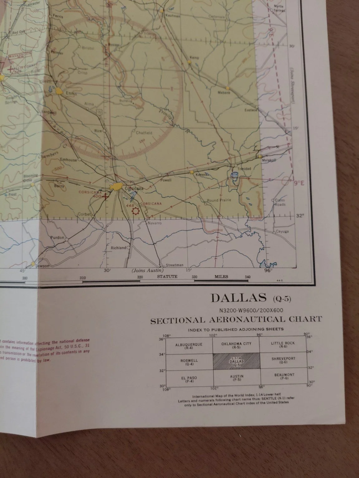
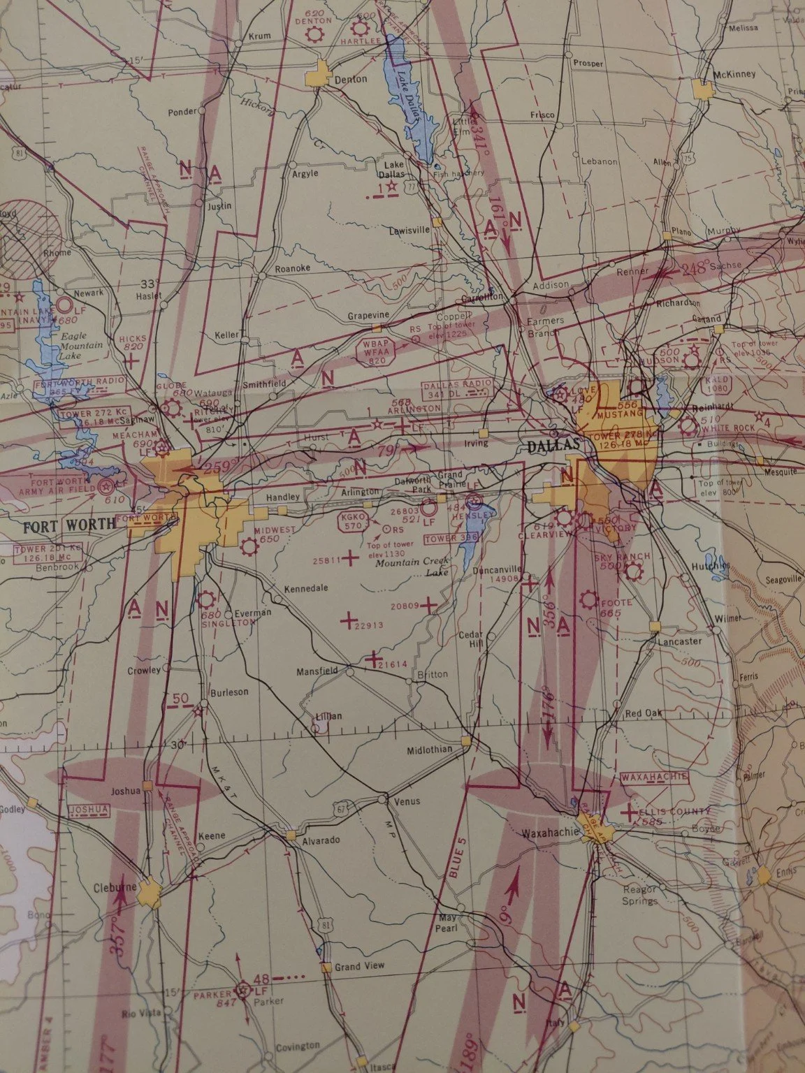
1944 Dallas Sectional Aeronautical Chart (Q-5 Restricted) – WWII Aviation Map
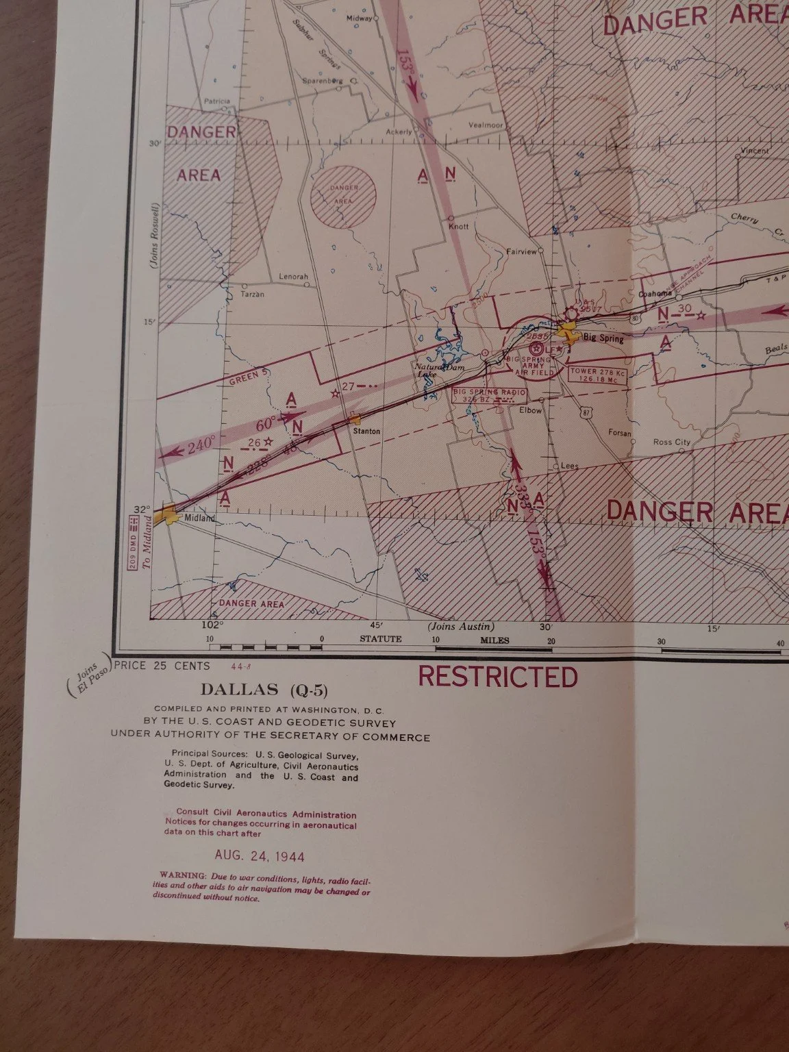
This is an original World War II sectional aeronautical chart (Dallas Q-5), dated August 24, 1944, compiled and printed in Washington, D.C. by the U.S. Coast and Geodetic Survey under authority of the Secretary of Commerce. These charts were critical navigation tools for both military and civilian aviators during the war, providing detailed topographic, navigational, and restricted-zone data at a time when American skies were heavily regulated for defense.
Historical Context
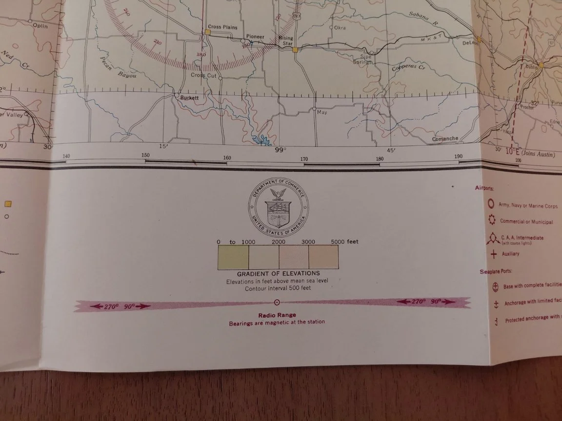
During WWII, the U.S. implemented strict controls over airspace, particularly in defense-critical regions. This map is boldly marked “RESTRICTED”, and contains Danger Areas, Caution Zones, Radio Ranges, Airfields, and Prohibited Flight Areas, all intended to protect military installations and prevent civilian overflights of sensitive areas.
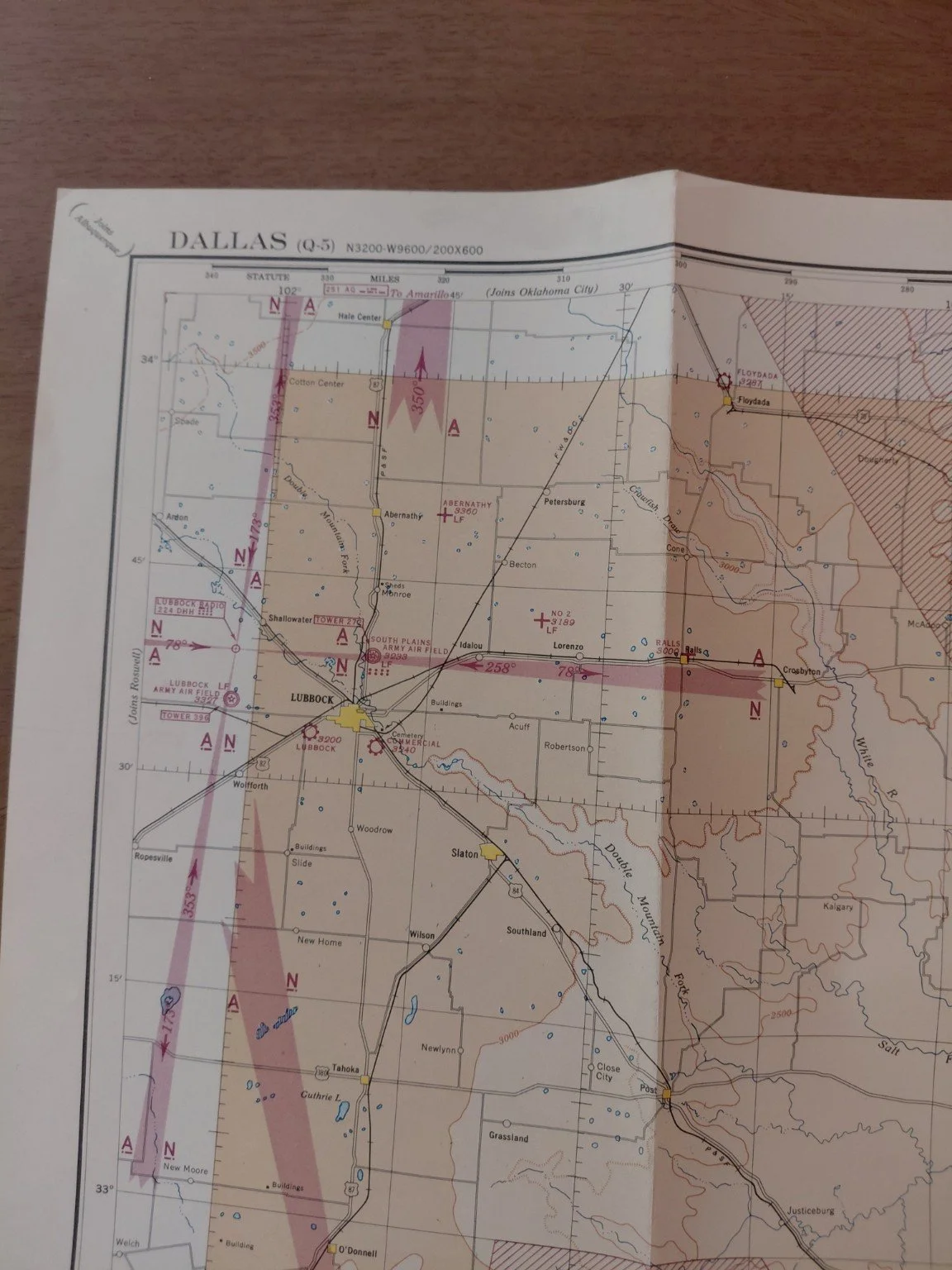
The Dallas–Fort Worth region was a major aviation hub in 1944, home to Love Field (Dallas), Meacham Field (Fort Worth), Fort Worth Army Airfield, Big Spring Army Airfield, South Plains Army Airfield (Lubbock), and many auxiliary training fields. This chart illustrates the dense concentration of radio navigation ranges and flight corridors connecting North Texas to the rest of the U.S.
Map Details
Title: Sectional Aeronautical Chart – Dallas (Q-5)
Date of Issue: August 24, 1944
Coverage Area: North Texas including Dallas, Fort Worth, Waco, Corsicana, Lubbock, Big Spring, and Midland
Original Printed Price: 25¢
Scale: 1:500,000 (approx. 1 inch = 7.89 miles)
Sources: U.S. Geological Survey, U.S. Department of Agriculture, Civil Aeronautics Administration, U.S. Coast and Geodetic Survey
Features:
Radio Ranges (LF/MF navigation beacons)
Civil, municipal, and military airfields
Restricted Danger Areas
Elevation contours and gradient shading
Highway and railroad networks for reference
Index to adjoining sectional sheets (Austin, Oklahoma City, Roswell, El Paso, Beaumont, Little Rock, Shreveport, Albuquerque)
Condition
Folded as originally issued
Excellent color preservation — reds, yellows, and purples remain sharp and vivid
Minor fold wear consistent with age
No tears, stains, or burns (much cleaner than earlier 1943 examples)
Overall: Very Good to Excellent condition
Collector Significance
Original WWII “Restricted” aviation maps are increasingly scarce. Most were discarded or destroyed after the war, and surviving examples often show heavy use, damage, or annotations. This Dallas 1944 issue is particularly desirable as it covers one of the most important U.S. aviation centers during WWII, at a moment when North Texas was training thousands of U.S. Army Air Forces pilots and playing a pivotal role in aircraft production and deployment.
This is an original World War II sectional aeronautical chart (Dallas Q-5), dated August 24, 1944, compiled and printed in Washington, D.C. by the U.S. Coast and Geodetic Survey under authority of the Secretary of Commerce. These charts were critical navigation tools for both military and civilian aviators during the war, providing detailed topographic, navigational, and restricted-zone data at a time when American skies were heavily regulated for defense.
Historical Context
During WWII, the U.S. implemented strict controls over airspace, particularly in defense-critical regions. This map is boldly marked “RESTRICTED”, and contains Danger Areas, Caution Zones, Radio Ranges, Airfields, and Prohibited Flight Areas, all intended to protect military installations and prevent civilian overflights of sensitive areas.
The Dallas–Fort Worth region was a major aviation hub in 1944, home to Love Field (Dallas), Meacham Field (Fort Worth), Fort Worth Army Airfield, Big Spring Army Airfield, South Plains Army Airfield (Lubbock), and many auxiliary training fields. This chart illustrates the dense concentration of radio navigation ranges and flight corridors connecting North Texas to the rest of the U.S.
Map Details
Title: Sectional Aeronautical Chart – Dallas (Q-5)
Date of Issue: August 24, 1944
Coverage Area: North Texas including Dallas, Fort Worth, Waco, Corsicana, Lubbock, Big Spring, and Midland
Original Printed Price: 25¢
Scale: 1:500,000 (approx. 1 inch = 7.89 miles)
Sources: U.S. Geological Survey, U.S. Department of Agriculture, Civil Aeronautics Administration, U.S. Coast and Geodetic Survey
Features:
Radio Ranges (LF/MF navigation beacons)
Civil, municipal, and military airfields
Restricted Danger Areas
Elevation contours and gradient shading
Highway and railroad networks for reference
Index to adjoining sectional sheets (Austin, Oklahoma City, Roswell, El Paso, Beaumont, Little Rock, Shreveport, Albuquerque)
Condition
Folded as originally issued
Excellent color preservation — reds, yellows, and purples remain sharp and vivid
Minor fold wear consistent with age
No tears, stains, or burns (much cleaner than earlier 1943 examples)
Overall: Very Good to Excellent condition
Collector Significance
Original WWII “Restricted” aviation maps are increasingly scarce. Most were discarded or destroyed after the war, and surviving examples often show heavy use, damage, or annotations. This Dallas 1944 issue is particularly desirable as it covers one of the most important U.S. aviation centers during WWII, at a moment when North Texas was training thousands of U.S. Army Air Forces pilots and playing a pivotal role in aircraft production and deployment.